
Advanced Navigation, a provider of Assured Positioning, Navigation, and Timing (APNT) technologies & autonomous systems, has successfully demonstrated its inertial-centric intelligent navigation capabilities as part of the U.S. Army’s All-Domain Persistent Experiment (APEX).
The sixth annual APEX event at the U.S. Army’s premier test range evaluates mission resilience across PNT, sensing, communications, data transport, and edge processing in realistic, GPS-denied multi-domain scenarios.
The exercise provided an operationally relevant Degraded, Denied, Intermittent and Low-bandwidth (DDIL) testbed to evaluate the performance of the Boreas D90 Fibre-Optic Gyroscope (FOG) Inertial Navigation System (INS) when fused with complementary sensors, including a Laser Velocity Sensor (LVS) and a wheel speed encoder. The results reaffirm Advanced Navigation’s intelligent software-defined approach as a resilient foundation for APNT on the modern battlefield.
Chris Shaw, Advanced Navigation CEO, said, “In today’s contested environment, the adversary will deny, degrade, and spoof GNSS signals. Relying on a single technology for navigation is a mission-ending vulnerability. Assured PNT is non-negotiable. The only path to operational advantage is an intelligent, multi-sensor fusion anchored by a resilient inertial core. We deliver this with our sophisticated AdNav Intelligence software.
It is the adaptive nervous system for your platform. It continuously validates all sensor inputs, adjusts in real time to the operational environment, and autonomously counteracts spoofing and jamming. This ensures unwavering PNT integrity, enabling you to operate decisively through an evolving, multi-domain threat landscape.
Now in our third year participating in this U.S. Army program, APEX continues to challenge our systems under realistic electronic warfare conditions. We’re honoured to collaborate with the U.S Army to help better prepare warfighters’ mission readiness for complex multi-domain operations.”
Boreas D90
At the centre of the architecture is Boreas D90, a strategic-grade FOG INS that serves as the “nervous system” of the navigation stack. Boreas D90, unlike conventional systems reliant on GNSS or magnetic compasses, determines true North through gyrocompassing, using ultra-sensitive fibre-optic gyroscopes to detect the Earth’s rotation. This enables independent, high-confidence navigation, even when external GNSS signals are compromised.
Countering Electronic Warfare
Completing this layered, inertial-centric architecture is AdNav Intelligence, the company’s sophisticated software, which can adapt in real time to respond to incoming threats. Using advanced algorithms, the navigation software dynamically weighs the input from each sensor, making real-time adjustments on which sensor to rely on based on their reliability scores, environmental conditions, and operational context. By championing a software-defined hardware philosophy, the solutions ensure continuous, high-confidence state estimation even when signals are disrupted, degraded, or denied.
Demonstration Setup with Aiding Technologies
During APEX, Boreas D90 with AdNav Intelligence was integrated with both an LVS and a wheel speed encoder aboard a four-wheel-drive vehicle. The demonstration was conducted during night operations at a site in rural New Mexico, USA, at which event organisers created an environment of complex and emerging electronic warfare threats by conducting GNSS jamming.
LVS: Precision Velocity for High-Demand Operations
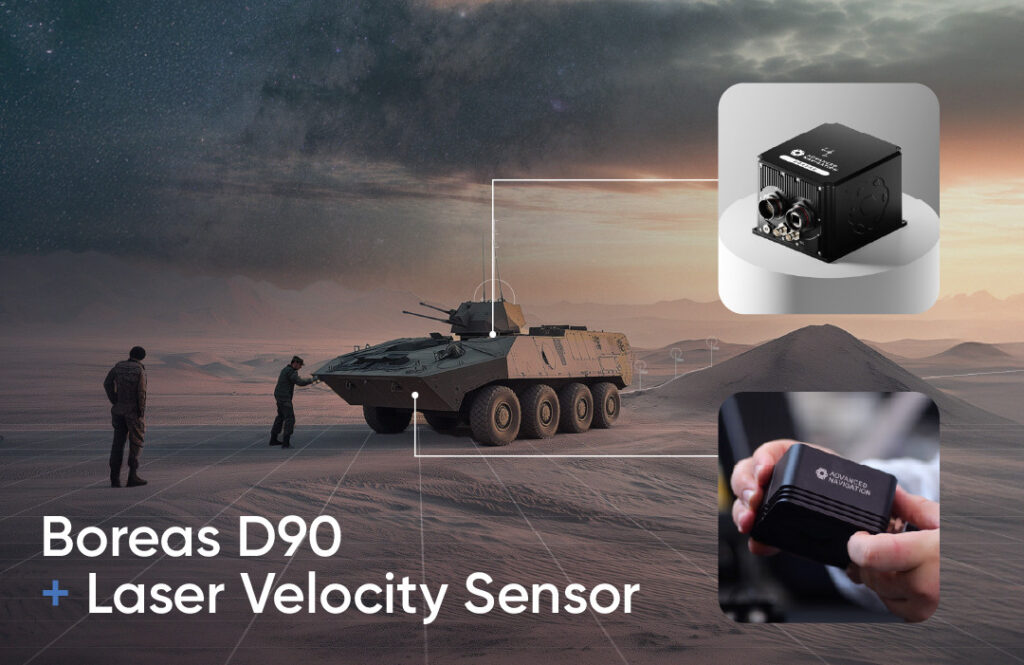

For operations requiring extreme accuracy and dynamic performance, Boreas D90 was fused with LVS – Advanced Navigation’s advanced infrared laser sensor that measures ground-relative 3D velocity with exceptional precision.
LVS performs reliably on both ground and airborne platforms regardless of environmental conditions or the availability of visual references, as long as it maintains a clear line of sight to the ground or a stationary surface. By providing direct, drift-free velocity measurements, LVS ensures continuous, high-precision mobility and enhances navigation resilience even in the most extreme contested GNSS environments.
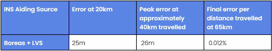
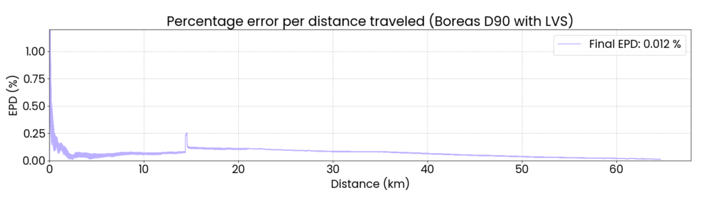
This configuration demonstrated best-in-class dead-reckoning accuracy, achieving a 0.012% error per distance traveled (7.5 m over 65 km) in the same contested conditions.
Wheel Speed Encoder
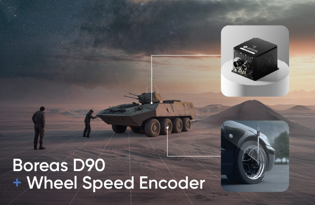
Wheel speed encoders offer a rugged and cost-effective source of motion data, measuring wheel rotation to determine ground speed and distance travelled. Their design ensures quick integration across tactical platforms. Ideal for firm terrain and structured routes, they provide dependable dead-reckoning performance when GNSS is denied, making them a practical choice for missions that demand reliability over complexity.
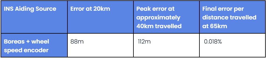
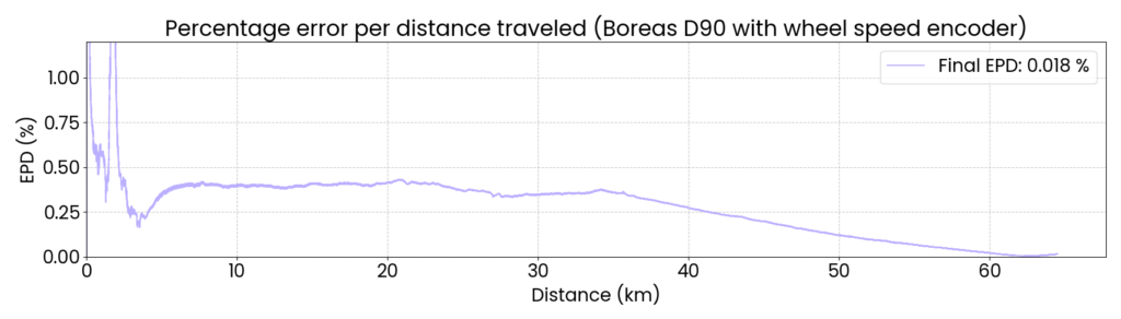
When paired with a wheel speed encoder, Boreas D90 delivered reliable dead-reckoning performance ideal for platforms operating in predictable or structured environments. Across the demonstration, the Boreas D90–wheel encoder configuration maintained strong navigation continuity, achieving a 0.018% error per distance travelled (11.7 m over 65 km), without reliance on GNSS, even under deliberate jamming.
APNT Technology’s Next Steps
For Advanced Navigation, the APEX results confirm the accuracy and reliability required for GNSS-denied environments. These trials mark a baseline for future development, specifically regarding the integration of inertial systems with next-generation photonics to enhance battlefield resilience. Moving forward, collaborative events like APEX will remain key in shaping future assured PNT solutions.
The next experiment will include partners within the United States Air Force’s 746th Test Squadron and the Joint Navigation Warfare Center, U.S. Army Combat Capabilities Development Command, and the Army Test and Evaluation Command. Advanced Navigation looks forward to returning in 2026.
The post Advanced Navigation Demonstrates Inertial-Centric Navigation in U.S. Army Exercise appeared first on Unmanned Systems Technology.
发布者:Olivia Hannam,转转请注明出处:https://robotalks.cn/advanced-navigation-demonstrates-inertial-centric-navigation-in-u-s-army-exercise/