
Underwater mapping software forms the digital backbone of autonomous hydrographic systems and subsea survey operations. These systems ingest data from multiple underwater sensors, including Multibeam Echo Sounders (MBES), Synthetic Aperture Sonar (SAS), sub-bottom profilers, laser scanners, and underwater LiDAR, combining them with Inertial Navigation Systems (INS) and DVL inputs to deliver accurate, geo-referenced seabed models. Increasingly, optical, acoustic, and hyperspectral camera data are also integrated to provide texture and reflectivity information for true-color 3D reconstructions.
Marine mapping software is now expected to process data in near real time, using onboard computing or ship-based servers to produce preliminary bathymetry and mosaics during the mission. Edge computing modules aboard Autonomous Underwater Vehicles (AUVs) and Unmanned Surface Vessels (USVs) compress, filter, and grid data in real time, minimizing bandwidth use and accelerating verification workflows. This allows operators to verify coverage, optimize survey routes, and correct positioning drift before completing the survey.
When integrated into marine control systems, underwater mapping software supports adaptive mission planning driven by AI algorithms that dynamically adjust coverage based on terrain complexity and data quality, ensuring high-resolution coverage with minimal overlap or data loss.
Hydrographic Software & GIS Interoperability
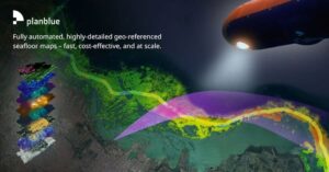

Fully-automated data products for underwater hyperspectral dataset analysis by PlanBlue.
Hydrographic software has evolved from post-processing toolsets into complete end-to-end environments that combine hydrographic survey equipment with enterprise-level GIS mapping capabilities. These solutions manage marine sonar and navigation inputs, perform motion compensation, and deliver gridded bathymetric surfaces that meet international hydrographic standards such as IHO S-44 for accuracy and S-100, S-102, and S-104 for data exchange and interoperability.
GIS mapping software integration enables seamless overlay of ocean floor maps with existing geospatial datasets such as cable routes, pipeline alignments, and UXO clearance zones. Advanced marine GIS modules manage vast bathymetric point clouds and raster mosaics, allowing users to query depth, slope, and seabed hardness directly within their spatial database. OGC-compliant data models and ISO 19115 metadata ensure that hydrographic and enterprise GIS systems interoperate cleanly within digital twin environments.
GIS-driven mapping environments now support 3D ocean floor visualization, time-series comparison, and automated change detection. These capabilities are vital for monitoring sediment transport, subsea asset stability, or post-installation seabed settlement. Cloud-based GIS servers host these datasets centrally, allowing global collaboration across survey teams and clients. As datasets scale, automated uncertainty modeling and CUBE surface algorithms validate accuracy orders to meet IHO and regulatory requirements.
Underwater Mapping Software for Subsea Pipelines & Infrastructure
Seabed mapping software is increasingly used to maintain and monitor subsea infrastructure. Pipeline mapping modules generate high-density sonar mosaics and 3D profiles of pipelines, risers, and manifolds, automatically identifying displacement, free spans, and potential damage zones. AI-driven anomaly detection enhances this process by flagging irregularities in pipeline geometry or corrosion patterns automatically, reducing manual interpretation.
Automated corrosion mapping functions quantify material degradation using sonar and laser intensity data, while GIS pipeline mapping tools integrate inspection logs, digital twin models, and engineering records for lifecycle management. Quality assurance layers track survey accuracy and repeatability. These datasets provide offshore energy operators with accurate spatial intelligence for integrity assurance and regulatory compliance.
Subsurface mapping solutions extend this capability below the seabed, processing sub-bottom profiler data to reveal burial depth, sediment layering, and structural voids. These tools support trenching verification, route assessment, and cable-protection planning, forming a vital input to asset management systems and environmental baselines.
Seafloor Mapping Software
Seafloor mapping software translates sonar returns into digital elevation models (DEMs) and backscatter mosaics representing the ocean floor’s topography and reflectivity. Combining MBES bathymetry with sidescan sonar imagery allows the generation of high-resolution 3D ocean floor maps and detailed texture analysis for environmental and engineering use.
Advanced algorithms classify seabed composition, from rock and sand to silt and biological material, supporting habitat mapping and environmental impact studies. AI-augmented classification engines now automate these processes, learning from historical training data to improve accuracy and reduce manual editing time. These ocean floor maps are critical for offshore wind, cable route planning, and defense navigation safety, delivering centimeter-level resolution for mission-critical decision making.
Modern mapping suites also include automated uncertainty propagation, coverage completeness checks, and compliance reports aligned with IHO S-44 accuracy orders, ensuring bathymetric models are defensible for charting and engineering use.
AUV & ROV Mapping Workflows

Global Mapper geospatial data analysis and GIS mapping software by Blue Marble Geographics.
Dedicated AUV mapping software handles the complexities of data collection in GPS-denied underwater environments. These systems integrate underwater acoustic positioning technology, inertial measurement, and Doppler velocity logging to maintain precise navigation throughout a survey. During post-mission processing, trajectory data is refined using SLAM (Simultaneous Localization and Mapping) algorithms, ensuring accurate positional correction across extended missions. The processed datasets are automatically fused with multibeam and sidescan sonar returns to produce uniform, geo-referenced mosaics and digital terrain models.
Edge computing and onboard AI modules now perform automated feature recognition and coverage assessment in real time, allowing adaptive mission replanning without human intervention. Cloud synchronization pipelines upload mission data directly from the vessel to onshore servers for collaborative review and digital twin integration.
Remotely Operated Vehicle (ROV)-based mapping workflows focus on close-range inspection and 3D reconstruction. Photogrammetric modules within underwater mapping suites combine optical camera data with laser scanning to generate detailed point clouds of subsea structures such as manifolds, foundations, and moorings. These outputs integrate with GIS and engineering CAD environments, enabling precise dimensional control and as-built documentation.
Subsurface Hazard & UXO Mapping
Underwater mapping software supports defense and decommissioning operations through UXO (unexploded ordnance) and subsea hazard mapping functions. By combining magnetometer, SAS, and sidescan sonar inputs, these systems can identify and classify anomalies with high confidence, generating GIS layers for clearance and risk assessment.
Machine-learning classification models assist in automated object detection, distinguishing UXO, debris, and geological features within sonar imagery. Advanced 3D visualization modules present layered subsurface and surface data, ensuring safe route planning for cable laying, dredging, or military maneuvers. Integration with S-101-compliant charting systems allows these hazard layers to flow directly into navigational products.
Ocean GIS Data Management, Cloud Processing, and Digital Twins
Ocean GIS environments serve as central repositories for bathymetric and survey data. By linking seabed, infrastructure, and environmental layers, operators gain a unified spatial understanding of subsea assets. Modern systems follow OGC and S-100 data exchange frameworks to ensure compatibility with enterprise and government geospatial platforms.
Cloud and edge processing architectures now underpin these environments. Data collected by AUVs and USVs is processed locally on edge nodes to reduce latency and then synchronized to cloud-hosted platforms for global access. These systems employ tiered storage, automated QC, and AI-based data compression, enabling near-real-time visualization even for multi-terabyte survey datasets.
Digital twin integration extends GIS beyond visualization. By linking hydrographic layers with live asset telemetry, environmental sensors, and inspection records, operators maintain dynamic digital twins of subsea installations. These twins support predictive maintenance, regulatory compliance, and long-term environmental monitoring.
Defense & Industrial Marine Mapping Software
Underwater mapping software plays a vital role in defense operations, providing digital seabed awareness for mine countermeasures, naval maneuver planning, and port security. GIS-integrated ocean floor maps allow fusion of bathymetric, acoustic, and optical datasets for tactical analysis. Defense systems increasingly incorporate AI-driven anomaly detection, automated object classification, and encrypted cloud-based data exchange.
In offshore energy, these systems enable inspection and maintenance of subsea production networks, wind turbine foundations, and inter-array cable corridors. Environmental agencies and marine scientists use the same mapping platforms for habitat classification, sediment transport modeling, and climate monitoring. Cloud deployment and automated QC workflows are expanding accessibility, reducing vessel time, and improving analytical consistency.
The convergence of hydrographic software, GIS mapping, AI automation, and autonomous vehicle control continues to expand operational efficiency, accuracy, and data throughput across all maritime sectors.
Providers of Underwater Mapping Software
Developers of underwater mapping software deliver modular, scalable platforms tailored for integration with AUVs, maritime drones, and crewed survey vessels. Core offerings include hydrographic data processing suites, GIS mapping systems, bathymetric visualization engines, and AI-driven feature extraction modules.
When selecting an underwater mapping software provider, opt for an end-to-end solution covering data capture, sensor fusion, motion correction, grid generation, and 3D visualization within secure, standards-compliant environments. Prominent providers now support S-100-based data structures, real-time cloud synchronization, and AI-assisted automation.
With increasing automation, cloud deployment, and digital twin integration, modern marine mapping software enables continuous, high-resolution understanding of the subsea environment, supporting defense, scientific, and industrial operations worldwide.
The post Underwater Mapping Software appeared first on Unmanned Systems Technology.
发布者:Eleanor Widdows,转转请注明出处:https://robotalks.cn/underwater-mapping-software/